.png)

Aerial Imaging, Mapping & Data
Actionable data with the highest degree of accuracy! We offer high-quality aerial imagery acquisition services, utilizing state-of-the-art digital sensors and highly trained, professional crews. Our skilled team ensures your project is delivered according to your requirements and specifications in a timely manner. We are committed to providing the most affordable, accurate, and efficient method to acquire and analyze your data. From nadir and oblique imagery acquisition to gyrostabilized EO/IR sensors and orthoimagery services, we provide comprehensive aerial imaging and mapping solutions. Our aircraft and experienced crews are also available for custom projects and mission needs.
AERIAL PLATFORMS

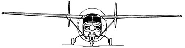


AERO COMMANDER 500S
Multi-Engine Fixed Wing
CESSNA SKYMASTER T337G
Multi-Engine Fixed Wing
CESSNA STATIONAIR T206H
Single-Engine Fixed Wing
CESSNA SKYHAWK 172S
Single-Engine Fixed Wing
DJI MATRICE 300 RTK
sUAS
Learn more about our aerial services! Call +1 (818) 906-4024